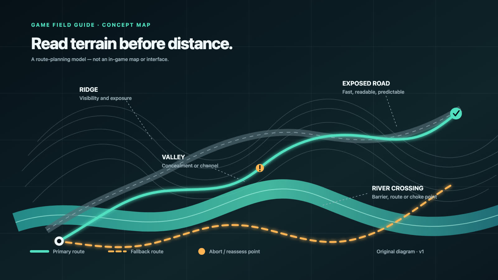
The Hell Let Loose: Vietnam Tactical Map is a fully 3D map generated from the game world. Its main advantage is terrain context: players can read elevation, valleys, obstacles, roads and rivers before choosing an infantry, vehicle or logistics route.
This guide explains the confirmed map design and a practical route-planning method. Exact controls, symbols, filters, zoom levels and marker permissions will be added after the August 13 release build is verified.
What is confirmed
In its July 23 developer Q&A, the team confirmed that:
- the Tactical Map is fully 3D;
- it is generated directly from the game world;
- roads, rivers and key terrain features have been made easier to distinguish;
- opening and closing the map was streamlined after beta feedback;
- performance improved across PC and console;
- hills, valleys and obstacles are intended to help commanders and vehicle crews plan;
- additional visual filters and presentation options were being explored for the future.
These are design facts, not a promise that every future filter will ship at launch.
Why the map is generated from the world
A traditional map can drift away from the playable environment when terrain changes during development. HLLV’s map is linked directly to the game world, so development changes can be reflected automatically.
For players, the useful consequence is alignment: the map is meant to represent the terrain being fought over, including elevation and waterways. It does not remove the need to confirm what is actually visible from ground level. Dense vegetation, smoke, destruction, enemies and friendly movement can still change a route.
Read terrain in layers
Do not begin by drawing the shortest line to the objective. Read the map in this order:
- Task: attack, defend, resupply, observe, move a vehicle or relocate.
- Elevation: identify high ground, low ground, valleys and steep transitions.
- Barriers: find rivers, dense terrain, obstacles and likely crossings.
- Movement network: compare roads, waterways and off-road approaches.
- Exposure: ask where a route can be observed or channelled.
- Alternatives: choose a primary route, fallback and abort condition.
This sequence converts a 3D picture into a decision.
Hills, valleys and obstacles
Elevation changes how quickly a unit moves, what it can see and where it may be seen. The 3D map is especially useful for comparing:
- a direct climb with a longer contour route;
- a valley approach with a ridge approach;
- a vehicle route with the terrain it can realistically cross;
- a firing or observation position with its exit route.
High ground is not automatically best. A crest may expose silhouettes, a valley may channel movement, and a steep slope may slow a vehicle. Use elevation to form a question, then confirm the answer through observation and squad reports.
Roads, rivers and waterways
The developer specifically says roads and rivers were made easier to distinguish after beta feedback. Vietnam’s environments include more varied waterways, and the official game description includes patrol boats.
Read these features as a movement network:
- Roads may improve speed and coordination but create predictable lanes.
- Rivers can be barriers, routes or crossing problems depending on available movement and vehicles.
- Bridges and narrow crossings can concentrate risk.
- A water route may help one faction’s logistics differently from another.
- A road that looks efficient for armour may be poor if the approach has no room to turn or withdraw.
Our US Forces vs NVA guide explains the confirmed difference between US helicopter logistics and NVA boat and tunnel systems.
Plan an infantry route
For infantry, use the map to keep the squad connected rather than optimize one player’s sprint.
- Identify the squad’s task and current rally point.
- Choose the next terrain feature, not only the final objective.
- Decide where the squad should slow down and observe.
- Mark or communicate the likely crossing, ridgeline or open ground.
- Choose a regroup point after the difficult section.
- Keep a fallback route that does not repeat a failed approach.
A route with two understandable legs is easier to communicate than “go north.” The exact marker system and who can place which marker remain launch-verification items.
Plan an armour route
Vehicle crews should use the 3D map to avoid committing before they understand elevation and obstacles.
Ask:
- Can the vehicle reach the route, or does the terrain only look passable from above?
- Where can it turn around?
- Where will it be forced into a narrow lane?
- Does the route provide a useful field of view?
- Where can infantry support connect with it?
- What is the withdrawal path if the task changes?
The official Q&A explicitly identifies commanders and vehicle crews as beneficiaries of the map’s terrain information. It does not publish final vehicle handling rules, so route decisions need in-match confirmation.
Plan helicopter and logistics movement
Steam confirms that the US has a Helicopter unit and the developer describes US helicopters delivering supplies, while NVA logistics include boats and tunnels.
For a helicopter task, the map can help frame:
- origin and destination;
- intervening high terrain;
- obvious approach corridors;
- the purpose of the delivery;
- an alternate destination;
- a return or abort route.
For ground or boat logistics, compare route continuity, crossings and exposure. Do not treat the Tactical Map as a flight-planning instrument with verified altitude, threat or landing data until those features are confirmed.
Role-by-role use matrix
| Player task | Read first | Decision to make | Ground confirmation |
|---|---|---|---|
| Infantry movement | Covering terrain and barriers | Next leg and regroup point | Visibility and enemy contact |
| Squad leadership | Objective, squad position and routes | Primary task and fallback | Member readiness and spawn state |
| Recon | Observation approaches and exits | Where information will be useful | Actual sightlines and concealment |
| Armour | Elevation, road geometry and obstacles | Advance, overwatch or withdraw | Passability and infantry support |
| Helicopter logistics | Terrain between origin and destination | Approach, alternate and abort | Landing area and current threat |
| NVA logistics | Waterways, ground routes and planned network | Supply path and redundancy | Current controls and build rules |
| Mortar support | Friendly and target context | Whether information is sufficient | Verified target and final firing system |
| Command | Multiple unit routes and terrain dependencies | Priority and coordination | Reports from squads and crews |
The role names are official. The workflow is editorial guidance and should be adapted to the final interface.
Readability and performance changes
The open beta produced feedback about usability and performance. The developer says it subsequently:
- made map access nearly immediate;
- improved visual distinction for roads, rivers and terrain;
- improved Tactical Map performance on PC and console.
Players who tested an earlier build should not assume the release map behaves exactly the same. Our best PC settings guide separates local graphics tests from server and interface symptoms.
Controls, markers and filters
The final controls section is intentionally held for launch verification. We still need to confirm:
- the default open/close binding on each platform;
- pan, rotate, tilt and zoom controls;
- controller behavior;
- available symbols and marker ownership;
- whether marker limits or cooldowns apply;
- which information is shared across squad and command channels;
- which visual filters ship at launch.
The developer said future filters were being explored, so they should not be described as a launch feature without evidence.
30-second route-planning checklist
Before committing:
- What is the task?
- What terrain feature controls the route?
- Where is the biggest barrier or crossing?
- Is the fastest route too exposed or too narrow?
- Where will the group slow, observe or regroup?
- What is the alternate?
- What ground report would make us change the plan?
For a first match, pair this checklist with the beginner guide. For vehicle, helicopter, mortar or leadership responsibilities, use the roles and classes guide.
Confirmed versus unknown
| Item | Status on July 29, 2026 |
|---|---|
| Fully 3D Tactical Map | Confirmed |
| Generated directly from game world | Confirmed |
| Improved roads, rivers and terrain readability | Confirmed |
| Faster access and performance work | Confirmed |
| Terrain use for commanders and vehicle crews | Confirmed |
| Final bindings and controller controls | Launch verification |
| Final symbols, permissions and marker limits | Launch verification |
| Additional visual filters | Future exploration; not confirmed for launch |
Version history
- July 29, 2026: Pre-release guide created from the July 23 official Dev Q&A.
- Next update: Release-build controls, marker behavior and original screenshots after August 13.
Return to the Hell Let Loose: Vietnam guide hub for the complete launch cluster.
Sources and verification
- Official Dev Q&A, July 23, 2026 — 3D map generation, usability, performance, terrain and future-filter discussion.
- Official Steam store page — factions, roles, vehicles and high-level logistics features.
Next verification: August 13, 2026 release build, or an earlier official Tactical Map tutorial.